Video of the former Canadian Northern Railway/CN-Kinghorn (Dorion) Subdivision (MP 83-87.3) at Macdiarmid/Biinjitiwaabik Zaaging Anishinaabek, ON. Features the grade as it passes alongside the communities with rock cuts, signage, crossings, culverts and the approaches to the Macdiarmid Tunnel. There are also beautiful views of Pijitawabik Bay of Lake Nipigon.
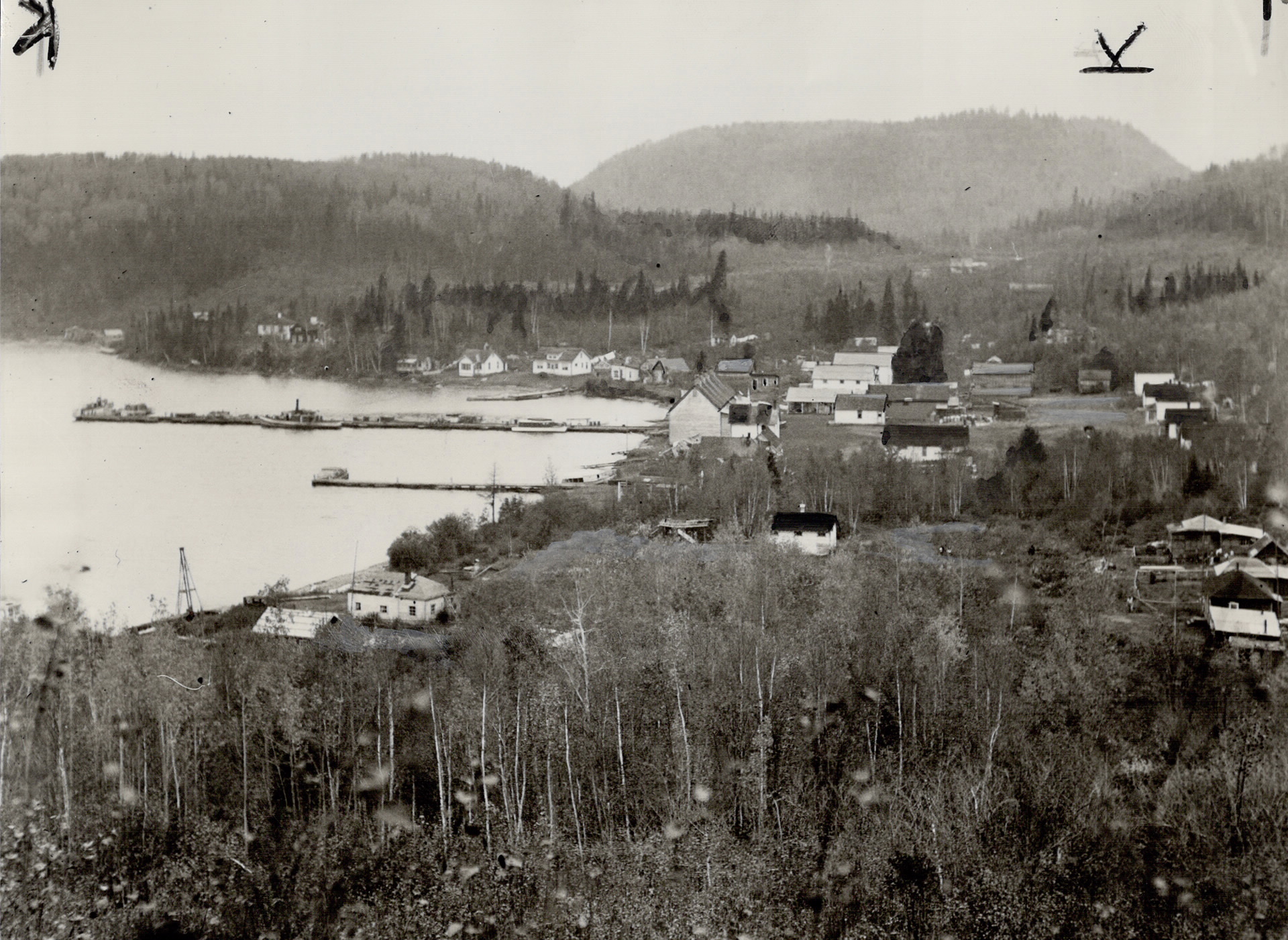
A photograph of the community of Macdiarmid, ON as it appeared in 1934. The town site was established in 1911 as a construction camp for the Canadian Northern Ontario Railway which was completed in 1914 (not visible in the photo). By late 1917, a railway spur had been built at what was then known as Sand Point, which was later changed to Macdiarmid. The area was a hub for commercial fishing on nearby Lake Nipigon during World War I.
In the 1960s land was partitioned off on the north side of the community for the Indigenous people living there. Initially known as Rock Bay First Nation, today it is commonly referred to by its more traditional name, Biinjitiwabik Zaaging Anishinabek.
Toronto Star Photograph Archive
Macdiarmid, 1934 (Toronto Star Photograph Archive, Courtesy of Toronto Public Library)
Video of the former Canadian Northern Railway/CN-Kinghorn (Dorion) Subdivision (MP 83-87.3) near Macdiarmid/Biinjitiwaabik Zaaging Anishinaabek, ON. Features the grade between Farlinger (MP 34.9) and Macdiarmid Stations (MP 36.6) with a milepost marker, a telegraph pole and rock cuts, including a massive 1000-foot long, 50+foot high cut. There are also beautiful views of Pijitawabik Bay of Lake Nipigon.
Video of the former Canadian Northern Railway/CN-Kinghorn (Dorion) Subdivision (MP 83-87.3) at Bingwi Neyaashi Anishinaabek, ON. Features the grade between Fairloch (MP 33.6) and Farlinger Stations (MP 34.9) with rock cuts, cuttings, milepost markers, a telegraph pole and the spur at Farlinger. **After checking mileages, the location of Farlinger is 85-90 metres west of where it’s shown in the video.
Video of the former Canadian Northern Railway/CN-Kinghorn (Dorion) Subdivision (MP 83-87.3) at Bingwi Neyaashi Anishinaabek, ON. Features the grade at Fairloch Station (MP 33.6), with the remains of the siding, milepost marker and a mystery location.
Video of the former Canadian Northern Railway/CN-Kinghorn (Dorion) Subdivision (MP 79.3-83) at Bingwi Neyaashi Anishinaabek, ON. Features the grade as it travels southwest through an old flood plain with telegraph poles, insulators, ties, culverts and the start of the siding at Fairloch.
Video of the former Canadian Northern Railway/CN-Kinghorn (Dorion) Subdivision (MP 79.3-83) at Bingwi Neyaashi Anishinaabek, ON. Features the grade as it travels southwest through an old flood plain with telegraph poles, milepost markers and a concrete culvert over Fairloch Creek.
A construction scene on the Port Arthur, Duluth and Western Railway (PAD&W) circa 1892. The exact location is unknown, but the end of track was near North Lake at the time (Milepost 71).
A locomotive, pushing a flat car and coach sit on a siding. It is not possible to identify the engine (likely #2 or #3), but her tender is piled high with wood instead of coal. The occupants of the coach appear to be well-to-do and include what appears to be one youth and a woman, suggesting a possible special excursion. In August 1892 PAD&W Vice President D.F. Burk did visit the area as far as Gunflint Lake with his family.
Video of the former Canadian Northern Railway/CN-Kinghorn (Dorion) Subdivision (MP 79.3-83) near Bingwi Neyaashi Anishinaabek, ON. Features the grade as it travels southwest through an old flood plain with crossings, culverts and telegraph poles.
Video of the former Canadian Northern Railway/CN-Kinghorn (Dorion) Subdivision (MP 75.4-79.3) south of Beardmore, ON. Features the grade south of Warneford Station with embankments, cuttings, an old crossing and the remains of a massive 1999 forest fire .