Canadian Northern Railway Nipigon Subdivision
The Canadian Northern Railway Nipigon Subdivision began in Hector (later Jellicoe), Ontario and wound its way 147.9 miles to Port Arthur, Ontario.
While the Canadian Northern Railway between Ruel, Ontario and Port Arthur, Ontario was completed in 1914, it should be noted though that Mackenzie and Mann were very hesitant about constructing the line altogether. They estimated, quite correctly in the end, that it would not generate enough revenue to cover its operating costs. As early as 1904, they attempted to negotiate a running rights agreement with Canadian Pacific between Port Arthur and the east. When they failed to secure an agreement, their hand was forced, as it would be quite impossible to operate the company just based on western traffic. Canadian Northern needed a complete transcontinental line.
While no period numbers are available at the moment, a Royal Commission report prepared in 1916 gives some insight into the cost of construction. It was estimated that the cost to replace the line would range from $25,204,052 to $28,102,045, or $46,245 to $51,563 per mile. Adjusted for inflation, this equates to between $488,816,614 to $545,021,351, or $896,911 to $1,000,039 per mile.
As the line was nearing completion, five sites were selected to become divisional points, creating four subdivisions:
Capreol – Ruel Subdivision – Foley (Foleyet) – Oba Subdivision – Fitzbach (Hornepayne) – Long Lake Subdivision – Hector (Jellicoe) – Nipigon Subdivision – Port Arthur
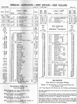
The Sudbury-Port Arthur line as it was called at the time, was opened for passenger traffic on October 15, 1915. In 1922, the Nipigon Subdivision became the Canadian National Railways Dorion Subdivision. In 1960, the Dorion and more eastern Kinghorn Subdivision were merged, and became the Kinghorn Subdivision, running from Longlac, Ontario to Port Arthur. The stations and some of the notable locations on the line are listed below (mileage shown is per the original line):
*Name changed **Planned but never constructed ***Added after 1996
In many ways, the fate of this line was sealed in 1923. That year, Canadian National completed a 30 mile section of line between Longlac, Ontario and Nakina, Ontario, known as the Nakina Cut-off. This connected the former Canadian Northern line to the former National Transcontinental Railway, which was built by the Canadian Government but operated by Grand Trunk. This construction created a route between Toronto and Winnipeg that was 100 miles shorter than the one via Port Arthur, and the grades were much better. Thus, CN’s main transcontinental line between Toronto and Winnipeg was the former Canadian Northern to Longlac, then the Nakina Cut-off and finally the former NTR line from Nakina to Winnipeg. All other lines in the area we relegated to secondary status.
The Kinghorn Subdivision managed to sustain traffic until 1990s when it decreased considerably, and the route became unprofitable. The acquisition of a US route south of the Great Lakes in the early 2000s by CN, coupled with the need for massive infrastructure upgrades, was the death blow for the line. The Kinghorn last saw traffic in May 2005 and the rails were removed from the entire line by 2010. While the right-of-way is still owned by CN, efforts have been underway for a number of years to transform parts of it into a rail trail.
For more information and photos, please read the following great articles:
The Driving of the Last Spike on the Canadian Northern Ontario Railway by John Todd (Canadian Rail Magazine, November 1979)
The Nipigon Tramway by John Todd (Canadian Rail Magazine, October 1977)
Link to 1921 & 1931 maps. Link to some of the timetables at Railway Pages and Traingeek. Link to the 1982 timetable. Link to the 1952, 1965 and 1990 systems maps. Other timetables courtesy of J. Smith and Ingenium.
Maps
-
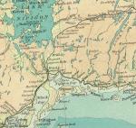
- Ontario & Quebec Rail Lines, 1915. (Atlas of Canada)
-

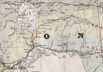
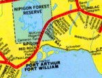
- CNoR Lake Nipigon area, circa 1915. (LAC Mikan 4129472)
-

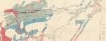
- CNoR East, 1916. (DRC)
-

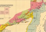
- CNoR East 1921 I (GSC)
-
- CNoR East 1921 II (GSC)
-
- Times Atlas, 1922.
-
- CNoR East, 1931. (GSC)
-

- CNoR East, 1931. (GSC)
-

- CN System Map, 1947.
-

- CNR System Map, 1952.
-
- CN System Map, 1965.
-

- CN System Map, 1990.
Timetables and Stations
-
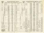
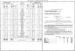
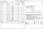
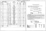
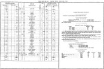
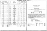
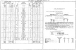
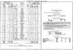
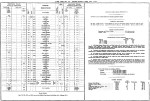
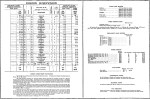
- Altitudes in Canada 1915 I
-

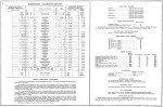
- Altitudes in Canada 1915 II
-

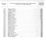
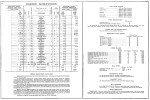
- CNoR Ontario Division, 1915.
-
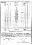
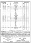
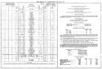
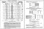
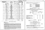
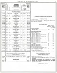
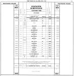
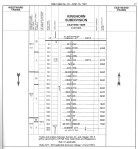
- CNoR Nipigon Subdivision Timetable, 1916.
-
- CNoR Timetable, 1917.
-
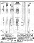
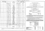
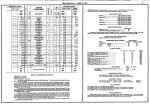
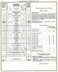
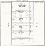
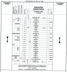
- CNoR Nipigon Subdivision Timetable, 1917.
-

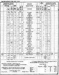
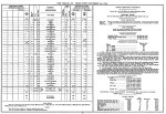
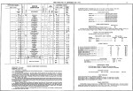
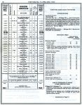
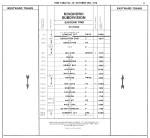
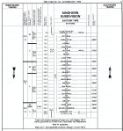
- CNoR Nipigon Subdivision Timetable, 1918.
-
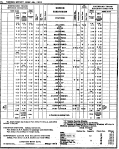
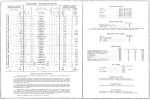
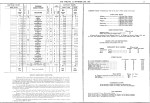
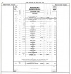
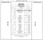
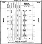
- CNR Nipigon Subdivision Timetable, 1919.
-
- CNR Nipigon Subdivision Timetable, 1920.
-

- CNR Nipigon Subdivision Timetable, 1921.
-
- CNR Dorion Subdivision Timetable, 1922.
-

- CNR Dorion Subdivision Timetable, 1923.
-
- CNR Dorion Subdivision Timetable, 1924.
-

- CNR Timetable, 1924.
-
- CNR Dorion Subdivision Timetable, 1925.
-

- CNR Dorion Subdivision Timetable, 1926.
-

- CNR Dorion Subdivision Timetable, 1927.
-

- CNR Dorion Subdivision Timetable, 1928.
-

- CNR Dorion Subdivision Timetable, 1929.
-
- CNR Dorion Subdivision Timetable, 1930.
-

- CNR Dorion Subdivision Timetable, 1931.
-

- CNR Dorion Subdivision Timetable, 1932.
-
- CNR Dorion Subdivision Timetable, 1933.
-
- CNR Dorion Subdivision Timetable, 1934.
-
- CNR Dorion Subdivision Timetable, 1935.
-
- CNR Dorion Subdivision Timetable, 1936.
-
- CNR Dorion Subdivision Timetable, 1937.
-

- CNR Dorion Subdivision Timetable, 1938.
-

- CNR Dorion Subdivision Timetable, 1939.
-

- CNR Dorion Subdivision Timetable, 1940.
-

- CNR Dorion Subdivision Timetable, 1941.
-
- CNR Dorion Subdivision Timetable, 1942.
-

- CNR Dorion Subdivision Timetable, 1943.
-

- CNR Timetable, 1943.
-
- CNR Dorion Subdivision Timetable, 1944.
-
- CNR Dorion Subdivision Timetable, 1945.
-
- CNR Dorion Subdivision Timetable, 1946.
-
- CNR Dorion Subdivision Timetable, 1947.
-
- CNR Dorion Subdivision Timetable, 1948.
-
- CNR Dorion Subdivision Timetable, 1949.
-
- CNR Dorion Subdivision Timetable, 1950.
-

- CNR Dorion Subdivision Timetable, 1951.
-
- CNR Dorion Subdivision Timetable, 1952.
-
- CNR Dorion Subdivision Timetable, 1953.
-
- CNR Dorion Subdivision Timetable, 1954.
-
- CNR Dorion Subdivision Timetable, 1955.
-
- CNR Timetable, 1956.
-

- CNR Dorion Subdivision Timetable, 1956.
-
- CNR Dorion Subdivision Timetable, 1957.
-

- CNR Dorion Subdivision Timetable, 1958.
-
- CNR Dorion Subdivision Timetable, 1959.
-
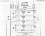
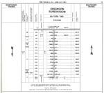
- CNR Kinghorn Subdivision Timetable, 1960.
-

- CN Kinghorn Subdivision Timetable, 1961.
-

- CN Kinghorn Subdivision Timetable, 1962.
-

- CN Kinghorn Subdivision Timetable, 1963.
-

- CN Kinghorn Subdivision Timetable, 1964.
-

- CN Kinghorn Subdivision Timetable, 1965.
-
- CN Kinghorn Subdivision Timetable, 1966.
-
- CN Kinghorn Subdivision Timetable, 1967.
-
- CN Kinghorn Subdivision Timetable, 1968.
-

- CN Kinghorn Subdivision Timetable, 1969.
-

- CN Kinghorn Subdivision Timetable, 1970.
-

- CN Kinghorn Subdivision Timetable, 1971.
-

- CN Kinghorn Subdivision Timetable, 1972.
-

- CN Kinghorn Subdivision Timetable, April 1973.
-

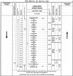
- CN Kinghorn Subdivision Timetable, October 1973.
-
- CN Kinghorn Subdivision Timetable, 1974.
-
- CN Kinghorn Subdivision Timetable, 1975.
-
- CN Kinghorn Subdivision Timetable, 1976.
-

- CN Kinghorn Subdivision Timetable, April 1978.
-
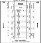
- CN Kinghorn Subdivision Timetable, October 1978.
-
- CN Kinghorn Subdivision Timetable, 1979.
-

- CN Kinghorn Subdivision Timetable, 1980.
-

- CN Kinghorn Subdivision Timetable, 1981.
-
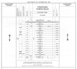
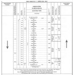
- CN Kinghorn Subdivision Timetable, June 1982.
-
- CN Kinghorn Subdivision Timetable, 1983.
-
- CN Kinghorn Subdivision Timetable, 1984.
-

- CN Kinghorn Subdivision Timetable, 1985.
-
- CN Kinghorn Subdivision Timetable, 1986.
-
- CN Kinghorn Subdivision Timetable, 1987.
-
- CN Kinghorn Subdivision Timetable, May 1988.
-
- CN Kinghorn Subdivision Timetable, October 1988.
-

- CN Kinghorn Subdivision Timetable, 1989.
-
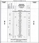
- CN Kinghorn Subdivision Timetable, 1990.
-
- CN Kinghorn Subdivision Timetable, 1991.
-
- CN Kinghorn Subdivision Timetable, 1992.
-
- CN Kinghorn Subdivision Timetable, 1993.
-

- CN Kinghorn Subdivision Timetable, 1994.
-
- CN Kinghorn Subdivision Timetable, 1996.
-

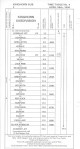
- CN Kinghorn Subdivision Timetable, 2005.
There are numerous videos of the remains of the CNoR-Nipigon Subdivision in the YouTube playlist below.
