Iron Mining
Although the Port Arthur, Duluth and Western Railway and the Paulson Mine were owned by different interests in different countries, the history of these two entities cannot be separated.
While originally intended to provide a link to Duluth and tap the silver mines southwest of Thunder Bay, the PAD&W would become a key outlet for the iron deposits in northern Minnesota. The existence of iron bearing rocks in the Gunflint Lake area was first mentioned as early as 1850 and confirmed by Cook County pioneer Hazael “Henry” Mayhew in 1886. As early as 1877, there was discussion of building a railway from the Canadian Lakehead into the area.
The land on which these deposits sat, were subsequently bought by the American Realty Company, which was started in Minneapolis in 1886 by John A. Paulson and Kristian Kortgaard. Both men hoped that this new iron area would become as profitable as the Vermillion Iron Range, which opened several years earlier. It was eventually confirmed that the Gunflint Iron Range, which stretched to the north of modern Thunder Bay, was an extension of the famous Mesabi Iron Range.
The spring of 1892 saw the nearing completion of the railway to the boundary at Gunflint Lake. In March of that year, the Gunflint Lake Iron Company was organized by Paulson, Kortgaard and Orrin D. Kinney of Ely, MN. In July 1892, the Gunflint Company and the railway signed a contract that would see one million tons of ore shipped to the Lakehead over ten years. Meanwhile, the rival cities of Port Arthur and Fort William competed with each other as to where the valuable ore docks would be located.
To reach the mine six miles across the border, a special line known as the PAD&W of Minnesota was created. The incorporators of the American line were Paulson, Kortgaard, James Conmee (contractor), Louis Reed, Freeman Lane and Matthew Walsh. It was intended that this line would be built through to Ely and a link with the Duluth & Iron Range Railroad. Construction concluded in late 1892 and the line opened in 1893.
The Gunflint Iron Company did considerable work in Sections 28 and 29 of Township 65 North, Range 4 West of Cook County. After digging several test pits, they sank a number of shafts, the primary one, known as the Paulson Shaft, was over 100 feet deep. It was reported that by early 1893, many tons of ore was ready to be shipped.
Approximately 350 metres southwest of the Paulson shaft was the main camp for the mining operations. It would eventually be christened “Gunflint City,” and it was hoped that it would grow into a metropolis due to the mines (much like nearby Leeblain, ON). It is featured prominently in an 1893 plat map published by the American Realty Company. Of the numerous structures at the site, the most intriguing was the one belonging to notorious Fort William madame Margaret “Mag” Matthews. Her “Hotel de Marguerite” was completed about the same time as the railway and was obviously intended to provide entertainment and comfort to the men working the mines.
Unfortunately, the whole venture fell apart very quickly. The Panic of 1893 caused a run on bank deposits, which led to the failure of the American Realty and Gunflint Iron Companies. By August 1893, both companies were in receivership and the careers of Paulson and Kortgaard were destroyed. Sadly, very little ore ever made it to Port Arthur. In August of 1893, the Premier of Ontario, Sir Oliver Mowat, visited the area and was taken on an excursion as far as Whitefish Station on the PAD&W. There his train was met by one from the Paulson Mine, carrying a flat car of iron ore, only enough to make a small horseshoe. The occasion was marked by a famous photograph.
There were plans to open mines along the Canadian portion of the Gunflint Range, but none of them ever achieved any tangible results.
Many attempts to re-open the mine were made over the next thirty years, all of which failed. The most intriguing occurred in 1921, when a group of Polish-American capitalists from Chicago formed the Palatine Mining and Development Company. They purchased or leased substantial mining rights in the area and arranged to rebuild 21 miles of the PAD&W (now owned by CNR) from North Lake Station to the mines. They also purchased a blast furnace in Port Arthur to smelt the ore. Unfortunately, the whole venture collapsed as quickly as it was devised.
The failure of iron mining was one of the major factors in the eventual demise of the PAD&W.
For more information, please visit the Paulson Mine Wikipedia page here.
To read about the geology of the area around the mines and Gunflint Lake, please read U.S. Grant’s Geology of the Akeley Lake and Gunflint Lakes Plates (Gunflint Plate follows the Akeley Plate in the book). It also has the second map below.
-
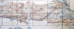
- Minnesota Topographic 1904
-
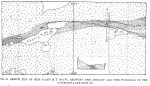
- Gunflint Mines 1893 (GoM)
-
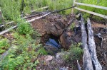
- Test pit, 2010.
-

- Test pit, 2010.
-
- Test pit, 2010.
-

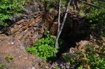
- Paulson Shaft, 2012.
-

- Paulson Shaft, 2012.
-

- Shaft, 2010.
-

- Akeley Lake Shaft, 2010.
-

- Gunflint City, 2010.
-

- Gunflint City, 1998.
-

- Gunflint City, 1998.
-

- Gunflint City, 1998.
There are several videos of the mines and Gunflint City from 1998 to the present in the YouTube playlist below.
