Canadian Northern Railway Port Arthur Subdivision
The Canadian Northern Railway Port Arthur Subdivision began in Port Arthur, Ontario and terminated in Atikokan, Ontario, 142.4 miles to the west.
This line west from the Lakehead has undergone many transformations since it opened for traffic in 1902, including a re-routing in 1911. The grade between Stanley and Kakabeka was particularly bad, so in 1909, CNoR decided to build a new section of line from Rosslyn to Kakabeka. The new route was shorter and the grades much easier. The new junction point became Twin City (MP 11.8) and the 3.94 miles of track from Stanley to Kakebeka was abandoned. Because of its incline, the old route was known as “High Track.”
The line is still active. The portion from Thunder Bay to Atikokan, Ontario is known as the CN-Kashabowie Subdivision. From 1925 to 1994, the first 35 miles of the subdivision carried traffic for two lines; the Kashabowie Subdivision and the Graham Subdivision. The Graham Subdivision was originally the Lake Superior Branch of the Grand Trunk Pacific Railway, which connected to the National Transcontinental Railway at Superior Junction. The Graham Subdivision was created by re-routing the line and abandoning the eastern 26 miles of track between the Mattawin River and Fort William (Thunder Bay). To accommodate the traffic and link with the old GTPR line, a second track was added between the Neebing Yard and Conmee Junction and a combination truss/pier bridge was built over the Mattawin River. The Graham Subdivision was abandoned in 1994 and the double track was reduced to a single line.
| Milepost | Station, Siding or Point | Elevation (ft.) |
| 0 | Port Arthur | 615 |
| 3 | Fort William | 613 |
| 6 | Westfort* | 632 |
| 8.5 | Neebing Yard | 654 |
| 11.8 | Twin City Junction | 723 |
| 13 | Slate River/Rosslyn** | 727 |
| 19 | Stanley** | 720 |
| 19-23 | High Track** | 915 |
| 23.4 | Kakabeka | 915 |
| 35.7 | Conmee Junction | 1097 |
| 142.4 | Atikokan | 1284 |
*Bypassed **Bypassed 1911
For more information and photos, please read the following great article:
The Driving of the Last Spikes on the Canadian Northern Railway in New Ontario by John Todd (Canadian Rail Magazine, October 1979)
Link to 1921, 1925, 1929 & 1931 maps. Some timetables courtesy of Ingenium.
Maps
-
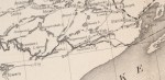
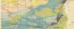
- CNoR West 1906 (DRC)
-

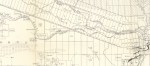
- Fort William, 1913.
-
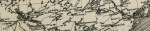
- CNoR West 1916 (DRC)
-
- CNoR West 1925 (GSC)
-
- CNoR West 1925 (GSC)
-
- CNoR West 1929 (GSC)
-
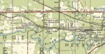
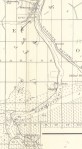
- Twin City area, 1953. (NTS)
-
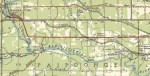
- Kakabeka area, 1953. (NTS)
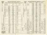
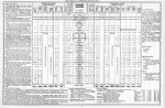
Timetables and Stations
-

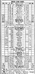
- CNoR Port Arthur Subdivision Timetable, September 1902.
-

- CNoR Timecard, 1904.
-

- CNoR Port Arthur Subdivision Timetable, October 1905.
-
- CNoR Timetable, 1910.
-

- CNoR Port Arthur Subdivision Timetable, 1911.
-
- CNoR Timetable, 1917.
-
- CNR Kashabowie Subdivision, May 1925.
There are several videos of the former grade between Twin City and Kakabeka in the playlist below:
