Video of the former Canadian Northern Railway/CN-Kinghorn (Dorion) Subdivision (MP 71.8-75.4) south of Beardmore, ON. Features the grade as it parallels the Blackwater River just east of Warneford Station with culverts and rock cuts. Also features a 1946 diversion of the grade which saw a 0.3 mile section of line shifted from the north bank of the river to the south bank and two trestles removed.
Many thanks to Jeffrey Smith who provided the information to locate this forgotten section of grade.
Video of the former Canadian Northern Railway/CN-Kinghorn (Dorion) Subdivision (MP 71.8-75.4) south of Beardmore, ON. Features the grade as it parallels the Blackwater River with rock cuts, cuttings, the Mount Regis stop and the remains of a massive 1999 forest fire.
Video of the former Canadian Northern Railway/CN-Kinghorn (Dorion) Subdivision (MP 71.8-75.4) south of Beardmore, ON. Features the grade as it parallels the Blackwater River with rock cuts, a milepost marker, a concrete culvert and the remains of a massive 1999 forest fire.
Extra Credit is video series that examines topics related to history in the Thunder Bay District and exploring that history.
The Global Positioning System has revolutionized many areas, including history and hiking. My experience with GPS dates back over 20 years and first started as a school curriculum requirement. Join me as I talk about my GPS receiver and head outdoors along the former Kinghorn rail line for the first ever field segment of Extra Credit.
*The current comparable Garmin model is the eTrex 32x.
Video of the former Canadian Northern Railway/CN-Kinghorn (Dorion) Subdivision (MP 71.8-75.4) south of Beardmore, ON. Features the grade as it parallels Highway 11 and the Blackwater River with rock cuts, a telegraph pole, a milepost marker and a concrete culvert.
Video of the former Canadian Northern Railway/CN-Kinghorn (Dorion) Subdivision (MP 69.1-71.8) south of Beardmore, ON. Features the grade as it skirts and crosses the Blackwater River on a 195-foot bridge. Further south, it passes through rock cuts, over the Warneford Creek and then alongside Highway 11.
Video of the former Canadian Northern Railway/CN-Kinghorn (Dorion) Subdivision (MP 69.1-71.8) south of Beardmore, ON. Features the grade as it skirts and crosses the Blackwater River with rock cuts, telegraph poles and a 100-foot bridge.
Video of the former Canadian Northern Railway/CN-Kinghorn (Dorion) Subdivision (MP 69.1-71.8) at Beardmore, ON. Features the grade as it cuts through the town and crosses Highway 11/Trans Canada Highway. Includes the remains of the siding, culverts, views of the Blackwater River and the famous Beardmore snowman.
Video of the former Canadian Northern Railway/CN-Kinghorn (Dorion) Subdivision (MP 69.1-71.8) at Beardmore, ON. Features the grade as it cuts through the town with culverts and crossings and remains of the siding, water tank, permanent slow order signs and station grounds. There is also information on the origins of the name of Beardmore.
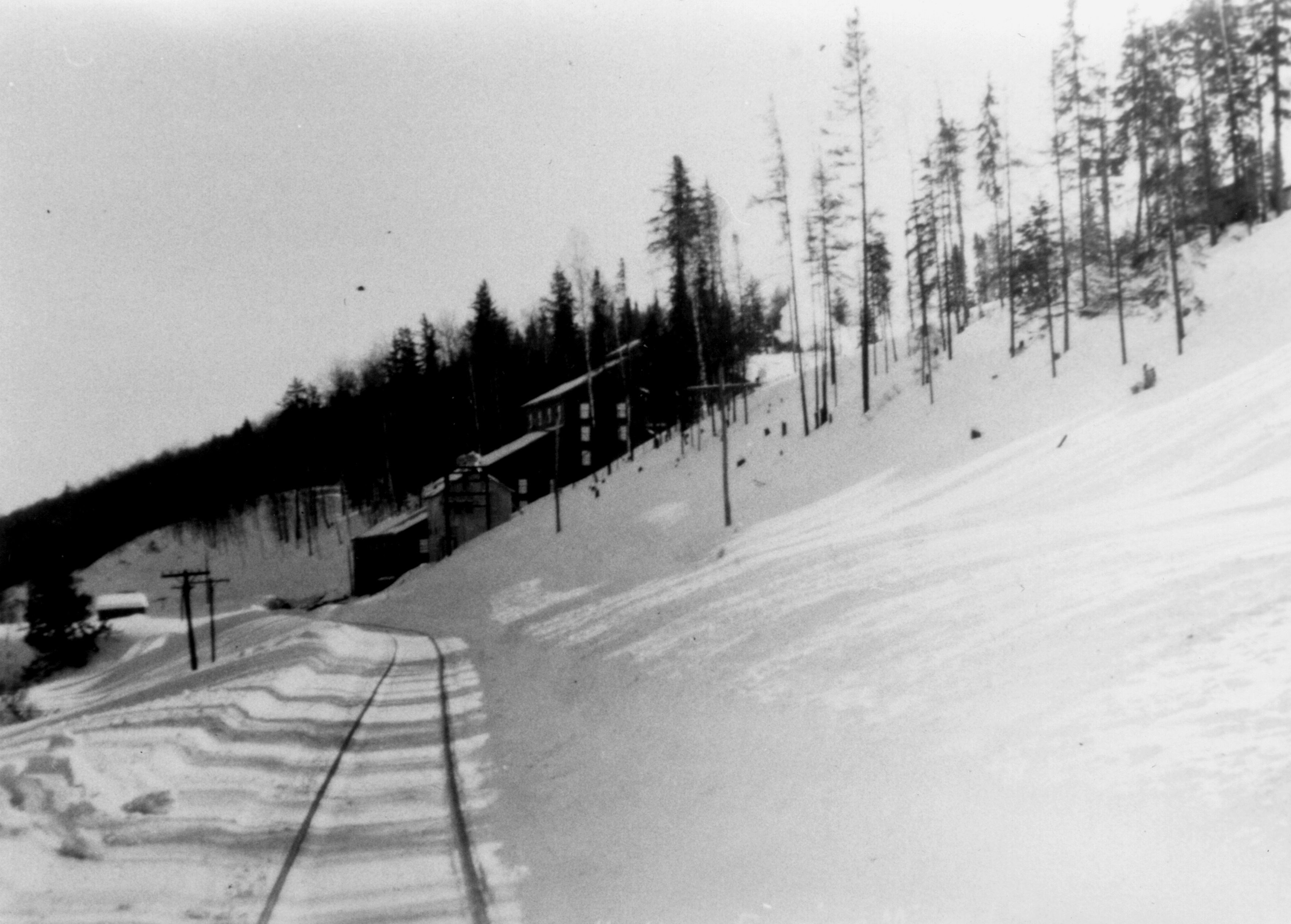
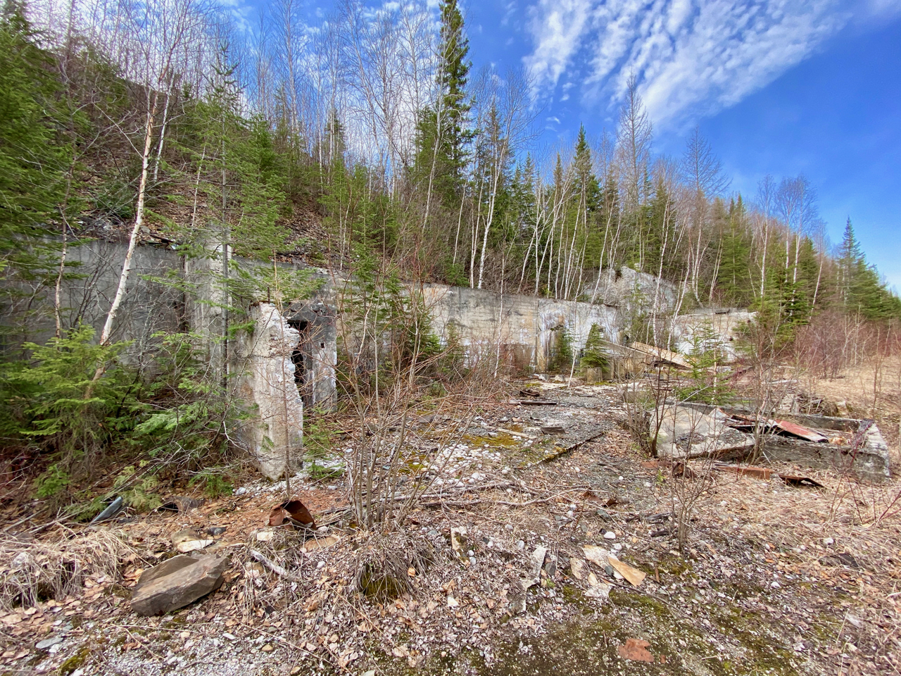
Then and now photos of the former Northern Empire Gold mine and railway line northeast of the community of Beardmore, ON. The first was taken in the 1930s when the mine went into operation looking east along the grade. The mine produced nearly 150,000 ounces of gold from 1934 to 1941.
The second photo was taken in May 2021 looking west at the remains of the concrete foundations. The mine was located at Milepost 19.8 of the then Canadian National Railways Dorion Subdivision (MP 69.5 of the later CN Kinghorn Subdivision).
Northern Empire Mine Mill, 1930s.Northern Empire Gold Mine, May 2021.