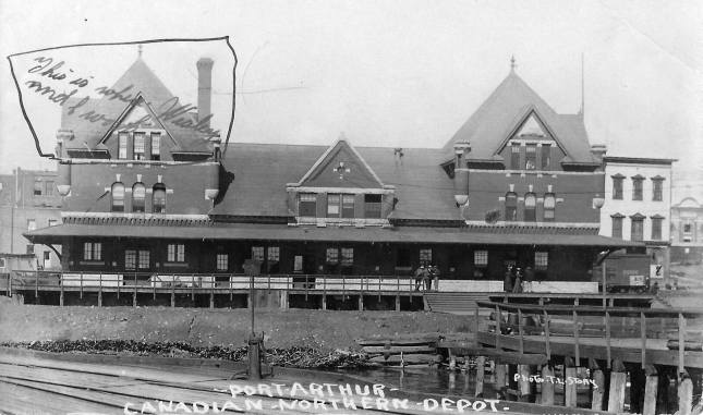
Does the writing say “This is where Wesley and I were… something?”.
Notice how the embankment in front of the station is a mess and leads down to a water area… and then the rails are separate. How would that have worked as a rail station?
Notice the buildings behind the rail station… what were they? …
I believe the writing says “This is where Welsey and I work.”
With regard to the station, the rail lines were actually located on the other (north) side of the station. The rails you are seeing in the photo are part of the wharfs and docks that were in the area. See this photo: https://padwrr.com/canadian-northern-railway/canadian-northern-railway-east/port-arthur/station-1920-cn-images-of-canada-collection/
Today a good chunk of that area has been infilled.
The buildings behind the station were hotels and business. There were actually two rail lines next to each other, those of the the Canadian Northern (later Canadian National) that served this station and the Canadian Pacific.

rickpotvin
February 28, 2022 at 19:40
Does the writing say “This is where Wesley and I were… something?”.
Notice how the embankment in front of the station is a mess and leads down to a water area… and then the rails are separate. How would that have worked as a rail station?
Notice the buildings behind the rail station… what were they? …
Any further analysis would be appreciated.
Rick Potvin
rick_potvin@yahoo.com
Padwrr
February 28, 2022 at 19:48
I believe the writing says “This is where Welsey and I work.”
With regard to the station, the rail lines were actually located on the other (north) side of the station. The rails you are seeing in the photo are part of the wharfs and docks that were in the area. See this photo: https://padwrr.com/canadian-northern-railway/canadian-northern-railway-east/port-arthur/station-1920-cn-images-of-canada-collection/
Today a good chunk of that area has been infilled.
The buildings behind the station were hotels and business. There were actually two rail lines next to each other, those of the the Canadian Northern (later Canadian National) that served this station and the Canadian Pacific.