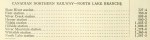
Stations
Throughout its history, the P.A.D & W had many different stations and stops along its 92 miles of tracks. This list represents a combined list that would have been in operation at different times between 1893 and 1938.
| Milage | Station, Siding or Stop | Features | Elevation (feet) |
| 0 | Port Arthur | Tank | 615 |
| 3 | Fort William | 613 | |
| 6 | Westfort | 632 | |
| 11.8 | Twin City Junction | 723 | |
| 13 | Slate River/Rosslyn (1904) | Wye | 727 |
| 19 | Stanley/Stanley Junction (1902-1912) | Tank | 720 |
| 22 | Harstone | 745 | |
| 25 | Flint | 780 | |
| 26.4 | Silver Creek | 807 | |
| 28.4 | Murdoch/Hymers | 877 | |
| 30.5 | Sellers | 913 | |
| 31.3 | Leeper | 1000 | |
| 34.1 | Nolalu | 1055 | |
| 35.9 | Hillside | 1096 | |
| 39.4 | Silver Mountain | 1282 | |
| 42.7 | Whitefish | Wye | 1348 |
| 44.4 | Wolfe (Suomi) | 1385 | |
| 47.1 | Mackies | Wye | 1445 |
| 52 | Round/Gravel Lake | 1550 | |
| 57 | Sand Lake (Sandstone) | Tank | 1541 |
| 60 | Iron Range | 1625 | |
| 65 | Addie Lake | Tank | 1609 |
| 71 | North Lake | Coal/Wye | 1572 |
| 83 | Leeblain | 1553 | |
| 85.8 | Gunflint (Gunflint Narrows) | Coal | 1568 |
| 89.8 | Round Lake, MN (switchback) | Wye | 1750 |
| 91 | Gunflint/Paulson Mine | 1810 |
Other places of interest:
| 20 | Stanley/Harstone Bridge | 730 | |
| 59 | Iron Range Hill | 1690 | |
| 74.8 | Trestle Bay | 1560 | |
| 79 | Gunflint & Lake Superior RR | 1567 | |
| 81.6 | Gunflint Retaining Wall | 1540 | |
| 84.5 | Gunflint Cross | 1560 |
-
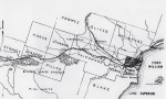
- PAD&W from Port Arthur to Whitefish Lake, 1893.
-
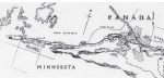
- PAD&W from Whitefish Lake to the Paulson Mine, 1893.
-

- PAD&W Proposed Extension 1893
-
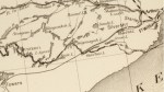
- PAD&W 1901 (DRC)
-

- Altitudes in Canada 1901
-
- CNoR West 1906 (DRC)
-
- CNoR 1906
-
- Altitudes in Canada 1915
-
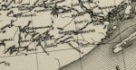
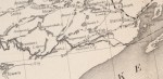
- PAD&W 1916 (DRC)
-
- CNoR 1917
-

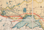
- Times Atlas, 1922.
-

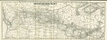
- PAD&W from Port Arthur to Whitefish Lake, 1931 (GSC)
-

- PAD&W from Whitefish Lake to North Lake, 1931 (GSC)
