Grand Trunk Pacific Railway
The parent company of the GTP was the Grand Trunk Railway (GTR), which was one of the earliest railway companies in Canada. It was incorporated in 1852.
Grand Trunk operated mainly in Ontario and Quebec, as well as some northeast and Midwest US states. Around the turn of the century, the company decided to expand into the western Canadian provinces to increase its profitability. It formed a partnership with the Canadian Government, whereby the government would build the eastern section of a transcontinental railway, from Winnipeg to Moncton, NB under the name National Transcontinental Railway (NTR). Grand Trunk would build the western section to Prince Rupert, BC as the Grand Trunk Pacific Railway (GTPR/GTP).
The one exception to this arrangement was the branch from NTR at Graham/Superior Junction (now Sioux Lookout, ON) to Fort William, ON. Construction on this 188-mile line, which would give Grand Trunk access to Lake Superior, began in 1905. It was completed in 1908 and became known as the GTPR-Lake Superior Division/Branch (it was also referred to as the Fort William Branch or Thunder Bay Branch). The contractors were the Foley Brothers, Larson and Company of Minnesota and purportedly the cost to build the line was close to 10 million dollars. During World War I, issues arose over the operation of the NTR, and in 1915 it and several others were consolidated into newly formed Canadian Government Railways (CGR). On July 1, 1915, the line was leased from Grand Trunk Pacific and became the CGR-Fort William Branch with two subdivisions; Fort William (Fort William to Raith 60.76 miles) and Raith (Raith to Superior Junction 131.33 miles). Numerous improvements were undertaken during these years, including the construction of concrete culverts and bridges, as well as the filling in of wood trestles with gravel, taken primarily from the Dona Pit (near Dona Station on the west bank of the Kaministiquia/Dog River).
In 1918, the CGR took over the Canadian Northern Railway (CNoR) and became the Canadian National Railways (CNR) on January 1, 1919, an arrangement which was finalized in 1923. The line initially was known as the CNR-Fort Willam and Raith Subdivisions, but was changed to the Lake Superior Subdivision by October 1919. In 1922, the name was changed yet again to the CNR-Graham Subdivision, but two years later it was split into the Crest and Graham Subdivisions (this will all be explained below). In 1925, it was split into 3 subdivisions; the Crest Subdivision ran from the junction with the Kashabowie Subdivision (MP 5) to the junction with the Raith Subdivision on the north bank of the Matawin River (MP 0.3), the Raith Subdivision ran from Conmee Junction to Graham, while the Quorn Subdivision continued from there to Sioux Lookout.
This unusual arrangement was the part of the nationalization process, whereby approximately 28 miles of the Crest Subdivision west from Fort William would soon be abandoned, which was a result of a duplication of lines with the former Canadian Northern Railway. To facilitate this arrangement, a new bridge was constructed across the Matawin River north of the Kashabowie Subdivison, which became Milepost 0 of the Raith Subdivision. The remaining two subdivisions were eventually remerged into the Graham Subdivision in 1931.
The beginning of the end of the line began in November 1985 with the termination of passenger service between Thunder Bay and Sioux Lookout (you can read more about it here) and the closure of the Griffith Mine and the Bruce Lake Subdivision in 1986. In 1991, the closure of the Mattabi Mine meant there was little to no traffic on the subdivision. The last train ran in November 1992 and CN began making preparations to close the line. After the formal committee process was complete, CN was given permission by the Canadian Transportation Agency to abandon the line on May 31, 1994. You can read the CTA decision here.
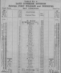
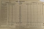
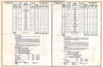
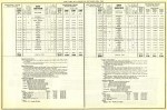
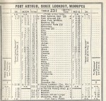
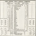
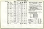
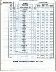
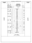
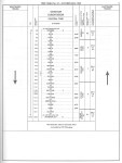
The stations and some of the notable locations on the line are listed below (mileage shown is per the original line):
| Milepost | Station, Siding or Point | Elevation (ft.) |
| 0 | Fort William* | 630 |
| 0 | Mission Terminal | 615 |
| Swing Bridge | 637 | |
| 0 | West Fort William* | 630 |
| 0.6 | CPR/CNoR Main Line Crossing | 636 |
| 1.3 | Empire Junction | 633 |
| 2.6 | Vickers Siding* | 643 |
| 5.6 | Neebing River Culvert* | 680 |
| 7-9.9 | Moose’s Nose* | |
| 6.2/8.5 | Alba** | 750 |
| 10 | Water Tank* | |
| 13.2 | Baird* | 920 |
| 20.9 | Crest* | 1084 |
| 25.8 | Strawberry Creek Bridge* | |
| 26.4 | Dona* | 1041 |
| 26.6 | Dog River Bridge* | 1039 |
| 27 | Dona Pit* | |
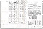
| Conmee Junction*** | 1097 | |
| Matawin River Bridge*** | 1097 | |
| 29.5 | Dog River*** | 1107 |
| 32.8 | Ellis | 1200 |
| 35.7 | Sunshine Creek Culvert | 1266 |
| 38.8 | Flett | 1357 |
| 39.8 | Flett Tunnel | 1378 |
| 44.5 | Water Tank | 1470 |
| 45.9 | East Oskondaga River Bridge | 1460 |
| 45.7 | Griff | 1445 |
| 49.1 | Water Tank | |
| 51 | Horne | 1487 |
| 53.8 | Horne Pit | 1535 |
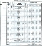
| 56.9 | Dexter/Raith**** | 1582 |
| 62.3 | Linko | 1555 |
| 63.4 | Great Lakes Paper Spur | 1552 |
| 67.8 | James | 1537 |
| 75.4 | Kelly | 1558 |
| 82.4 | Larson | 1567 |
| 88.3 | Mack | 1593 |
| 95.1 | George | 1670 |
| 99.6 | Knowlton/Graham**** | 1617 |
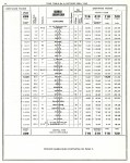
| 107.3 | Oscar | 1596 |
| 114.3 | Petry | 1520 |
| 122 | Quorn | 1465 |
| 127.1 | Reba | 1480 |
| 127.5 | Reba Pit | 1481 |
| 134.5 | Sowden | 1465 |
| 139.1 | Tannin | 1482 |
| 143.4 | Eva Lake Bridge | 1424 |
| 143.5 | Water Tank | 1424 |
| 145.3 | Unaka | 1446 |
| 146.3 | Unaka Pit | 1440 |
| 147.9 | Crystal River Bridge | 1404 |
| 148.5 | Mattabi | 1410 |
| 151.7 | Valora | 1407 |
| 153.1 | W.O. Junction/Clarkdon **** | 1430 |
| 155.3 | Sturgeon Lake Transportation Company | 1394 |
| 160.3 | Wako/Watcomb**** | 1338 |
| 160.5 | Watcomb Pit | 1338 |
| 166.6 | Hunt/Umfreville**** | 1304 |
| 170.8 | Yonde | 1338 |
| 178 | Zarn | 1311 |
| 178.8 | Martin Creek Bridge | 1295 |
| 185.2 | Alcona | 1237 |
| 188.8 | Superior, junction with NTR Main Line | 1209 |
| 192.7 | Bidwell***** | |
| 195 | Graham/Sioux Lookout**** | 1197 |
*Abandoned 1925 **Relocated ***Added 1924 ****Renamed *****Planned, but never constructed
For more information and photos, please read the following great article: The Grand Trunk Pacific’s Lake Superior Branch by John Todd (Canadian Rail Magazine, September 1976)
For more information and pictures the Lake Superior Branch stations on this line, please see: Canadian National’s Western Depots : The Country Stations in Western Canada by Charles Bohi
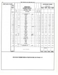
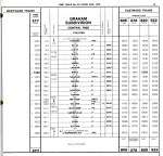
Link to 1929 & 1925 maps. Link to some of the timetables at Railway Pages and Traingeek. Link to the 1982 timetable. Link to the 1952, 1965 and 1990 systems maps. Other timetables courtesy of J. Smith and Ingenium.
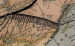
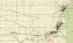
Maps
-
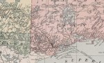
- Rand McNally Atlas, 1912.
-
- GTP, undated.
-

- Fort William, 1913.
-

- Atlas of Canada, 1915.
-

- GTP, 1916. (DRC)
-

- Times Atlas, 1922.
-
- GTP, Fort William to Baird, 1925. (GSC)
-
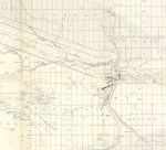
- GTP, Crest to Flett, 1925. (GSC)
-

- CN System Map, 1947.
-

- CN System Map, 1952.
-

- CN System Map, 1965.
-

- CN System Map, 1990.
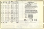
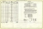
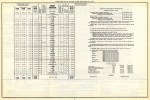
Timetables
-
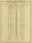
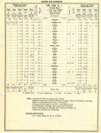
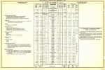
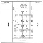
- GTP Lake Superior Division, November 1908. (LAC 1547906)
-
- GTP Timetable, July 1910. (G. Gaugl)
-
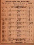
- GTP Timetable, August 1911.
-

- GTP Timetable, April 1912. (G. Gaugl)
-
- GTP Timetable, February 1913.
-

- Altitudes in Canada 1915
-

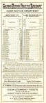
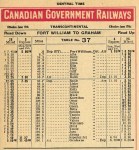
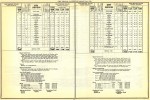
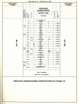
- CGR Fort William Subdivision, July 1915.
-
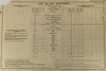
- CGR Raith Subdivision, July 1915.
-
- CGR Timetable, January 1916.
-

- CGR Timetable, June 1916.
-
- CGR Timetable, June 1917.
-
- CGR Fort William Subdivision, October 1918.
-
- CGR Raith Subdivision, October 1918.
-

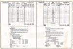
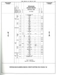
- CNR Fort William & Raith Subdivisions, February 1919.
-

- CNR Lake Superior Subdivision, October 1919.
-

- CNR Timetable, 1919.
-

- CNR Lake Superior Subdivision, June 1920.
-
- CNR Lake Superior Subdivision, February 1921.
-

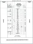
- CNR Graham Subdivision, June 1922.
-

- CNR Graham Subdivision, May 1923.
-

- CNR Timetable, 1923.
-

- CNR Graham Subdivision, January 1924.
-

- CNR Crest Subdivision, January 1924.
-

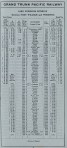
- CNR Raith & Quorn Subdivisions, May 1925.
-

- CNR Crest Subdivision, May 1925.
-
- CNR Raith & Quorn Subdivisions, January 1926.
-
- CNR Raith & Quorn Subdivisions, June 1927.
-
- CNR Raith & Quorn Subdivisions, June 1928.
-

- CNR Raith & Quorn Subdivisions, June 1929.
-
- CNR Raith & Quorn Subdivisions, September 1930.
-

- CNR Graham Subdivision, September 1931.
-

- CNR Graham Subdivision, September 1932.
-

- CNR Graham Subdivision, June 1933.
-

- CNR Graham Subdivision, September 1934.
-

- CNR Graham Subdivision, November 1935.
-

- CNR Graham Subdivision, November 1936.
-

- CNR Graham Subdivision, October 1937.
-
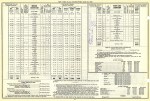
- CNR Graham Subdivision, June 1938.
-
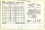
- CNR Graham Subdivision, September 1939.
-
- CNR Graham Subdivision, September 1940.
-
- CNR Timetable, 1940.
-
- CNR Graham Subdivision, November 1941.
-
- CNR Graham Subdivision, September 1942.
-

- CNR Graham Subdivision, September 1943.
-
- CNR Timetable, 1943.
-
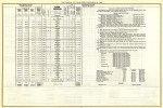
- CNR Graham Subdivision, September 1944.
-

- CNR Graham Subdivision, June 1945.
-
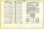
- CNR Graham Subdivision, December 1946.
-

- CNR Graham Subdivision, December 1947.
-

- CNR Graham Subdivision, November 1948.
-

- CNR Graham Subdivision, September 1949.
-
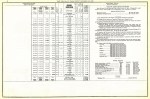
- CNR Graham Subdivision, November 1950.
-

- CNR Graham Subdivision, September 1951.
-
- CNR Graham Subdivision, September 1952.
-

- CNR Graham Subdivision, September 1953.
-

- CNR Graham Subdivision, September 1954.
-

- CNR Graham Subdivision, April 1955.
-
- CNR Graham Subdivision, September 1956.
-

- CNR Graham Subdivision, October 1957.
-

- CNR Graham Subdivision, October 1958.
-

- CNR Graham Subdivision, April 1959.
-

- CNR Graham Subdivision, April 1960.
-

- CNR Timetable, 1960.
-

- CN Graham Subdivision Timetable, October 1961.
-
- CN Graham Subdivision Timetable, October 1962.
-

- CN Graham Subdivision Timetable, October 1963.
-

- CN Graham Subdivision Timetable, October 1964.
-
- CN Graham Subdivision Timetable, October 1965.
-

- CN Graham Subdivision Timetable, October 1966.
-

- CN Graham Subdivision Timetable, October 1967.
-

- CN Graham Subdivision Timetable, April 1968.
-

- CN Graham Subdivision Timetable, April 1969.
-
- CN Graham Subdivision Timetable, April 1970.
-
- CN Graham Subdivision Timetable, April 1971.
-

- CN Graham Subdivision Timetable, October 1972.
-

- CN Graham Subdivision Timetable, October 1973.
-
- CN Graham Subdivision Timetable, April 1974.
-

- CN Graham Subdivision Timetable, April 1975.
-

- CN Graham Subdivision Timetable, April 1976.
-
- CN Graham Subdivision Timetable, April 1978.
-

- CN Graham Subdivision Timetable, June 1979.
-

- CN Graham Subdivision Timetable, September 1980.
-

- CN Graham Subdivision Timetable, June 1981.
-

- CN Graham Subdivision Timetable, June 1982.
-
- CN Graham Subdivision Timetable, October 1983.
-

- CN Graham Subdivision Timetable, October 1984.
-
- CN Graham Subdivision Timetable, October 1985.
-

- CN Graham Subdivision Timetable, December 1986.
-
- CN Graham Subdivision Timetable, June 1987.
-
- CN Graham Subdivision Timetable, May 1988.
-

- CN Graham Subdivision Timetable, October 1988.
-

- CN Graham Subdivision Timetable, April 1989.
-
- CN Graham Subdivision Timetable, January 1990.
-

- CN Graham Subdivision Timetable, May 1991.
-
- CN Graham Subdivision Timetable, October 1992.
-

- CN Graham Subdivision Timetable, April 1993.
There are numerous videos of the remains of the GTP in the YouTube playlist below.
